Massive 3.54-Inch Hailstorm Pounds Lake Amistad as Supercell Moves Toward Del Rio
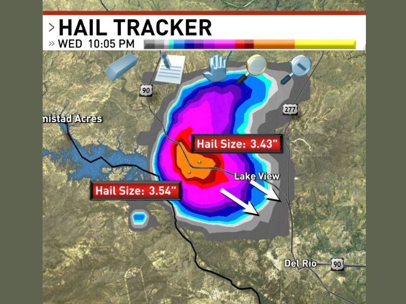
A powerful supercell thunderstorm unleashed giant hailstones measuring up to 3.54 inches in diameter over Lake Amistad, Texas at 10:05 PM, sparking immediate concern for communities in its path including Del Rio, Lake View, and Amistad Acres.
The hail reaches a catastrophic size capable of punching through rooftops, shattering vehicle windows, and causing widespread property damage. This latest supercell comes amid an ongoing severe weather outbreak across southern Texas, adding to a barrage of destructive storms in the region.
Supercell’s Core Centered Directly Over Lake Amistad
Storm data from Hail Tracker revealed two distinct giant hail measurements within the storm’s core: 3.54 inches and 3.43 inches. The deepest hail core was centered directly over Lake Amistad at the time of observation, indicated by intense hail tracker readings marked in deep red and magenta.
These enormous hailstones pose a severe threat to anyone caught outdoors, as well as to structures and vehicles. The storm’s force is capable of devastating roofs, smashing windows, and causing life-threatening injuries.
Supercell Heading Southeast Toward Del Rio Corridor
The supercell is moving southeast from Lake Amistad, putting Del Rio, Lake View, and Amistad Acres directly in its forward path. The trajectory raises alarm for significant damage across Del Rio, one of the largest urban centers in the area.
Beyond the hail core, a broad swath of damaging hail extends across the region, impacting a wide geographic area around the supercell’s most intense precipitation zone. Residents are urged to take shelter immediately as these destructive conditions develop.
Intense Weather Threat Escalates with Multiple Supercells
This severe hail-producing storm marks at least the second powerful supercell to strike the Del Rio and Lake Amistad corridor in quick succession. Back-to-back giant hail events paint a dire picture for the region’s communities, already reeling from prior storm impacts.
Experts warn that this active severe weather pattern could continue to generate more destructive storms, demanding heightened vigilance as emergency services monitor the situation closely.
What to Expect Next
Authorities and weather services continue tracking this supercell and others impacting southern Texas, providing updates to keep residents informed and safe. Those in the storm’s projected path should seek immediate shelter and avoid outdoor exposure.
For ongoing coverage and expert storm analysis from across the United States, stay tuned to credible sources and official updates.
“The size and intensity of this hail create an unprecedented threat to life and property in the affected areas,” officials say.
This severe weather event underscores the increasingly volatile storm patterns emerging in southern Texas, with potential ripple effects that may influence storm preparedness protocols nationwide, including in California and beyond.