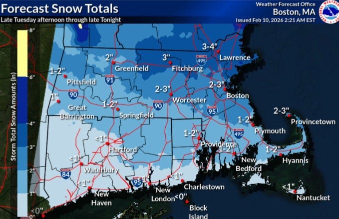
UPDATE: A powerful storm is set to blanket Rhode Island with 1 to 2 inches of snow this afternoon, according to the National Weather Service. Snowfall is expected to begin around Tuesday afternoon and continue into the night, bringing a mix of weather conditions to different parts of the state.
The northern regions of Rhode Island are predicted to receive the most accumulation, while the southern areas may experience a mix of rain and less than an inch of snow. Although this storm will not be a major snow event for Rhode Island, neighboring Massachusetts could see significant snowfall of 3 to 4 inches, particularly in the northeastern parts.
This latest storm follows a harsh winter pattern, as Rhode Island has already endured over 20 inches of snow in January and an additional 2.6 inches so far this February. The ongoing cold weather has hindered melting, leaving approximately 10 inches of snow still on the ground in the Providence area.
With February averaging at a frigid 19.9 degrees, temperatures have been 10.5 degrees below normal during the first nine days of the month. By contrast, January saw an average of 27.4 degrees, which is 2.8 degrees colder than usual.
Relief from the extreme cold is on the horizon, as the forecast indicates a high of 34 degrees for Providence on Tuesday, with temperatures expected to stabilize between 35 and 36 degrees through Saturday.
As residents prepare for the snowfall, officials are also monitoring the potential for another coastal storm this weekend, which could complicate conditions even further.
Stay tuned for the latest updates as the storm develops and to understand its impact on travel and daily life in Rhode Island.