Severe Storm Complex Closing In on Tulsa With High Risk of Wind Damage and Tornado
TULSA, OKLAHOMA — A powerful storm complex is rapidly advancing toward the Tulsa metro area and is expected to arrive within the next two hours as of 10:15 PM. Authorities warn of damaging winds capable of uprooting trees and downing power lines, along with very heavy rainfall that could cause dangerous flooding in low-lying areas. Most alarmingly, forecasters have not ruled out the possibility of a spin-up tornado as this storm system pushes eastward toward Tulsa and its suburbs.
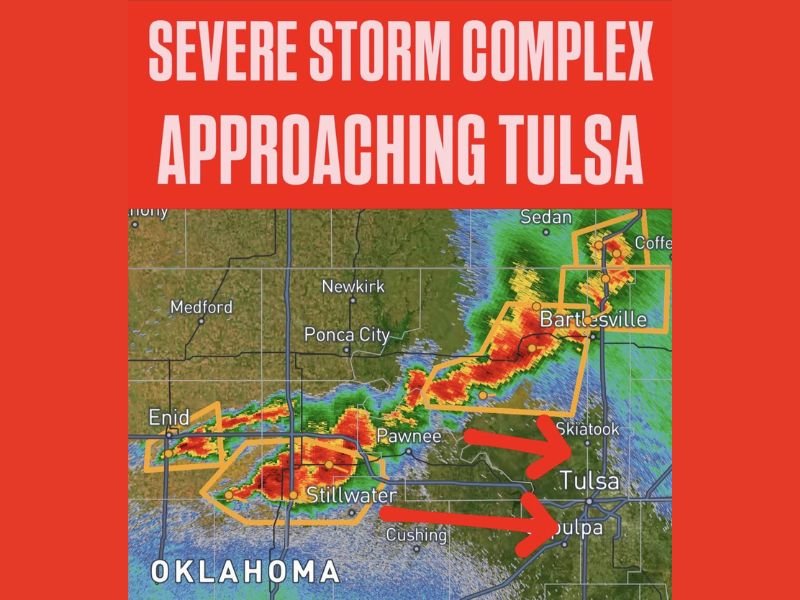
This severe weather event is unfolding across a broad corridor from Enid through Pawnee, Skiatook, and northern Tulsa suburbs. Radar imagery shows intense red and orange returns moving directly toward Tulsa from the west and northwest. Two primary storm cells are tracking east, one targeting downtown Tulsa directly, and another moving toward Sapulpa just south of the city. To the north, Bartlesville and Washington County remain under active severe weather warnings from a separate portion of the storm complex.
Immediate Threats: Destructive Winds, Flooding, and Tornado Risk
Forecasters emphasize that damaging winds represent the most immediate danger. These winds could cause widespread power outages, structural damage, and fell trees across the metropolitan area. Meanwhile, torrential downpours may trigger rapid water accumulation on streets, endangering motorists and residents in flood-prone zones.
Though a tornado is not the main threat, meteorologists explicitly caution that the storm system retains enough rotation to produce a spin-up tornado. All Tulsa-area residents must treat this as a potential tornado event and seek shelter on the lowest floor of a sturdy interior building without delay.
Communities in the Storm’s Direct Path Tonight
The worst-affected communities based on current radar data include Skiatook, Tulsa, and Sapulpa. The storm cells are expected to pass through these areas imminently, bringing the highest risk for wind damage and flash flooding. To the north, the Bartlesville corridor remains under severe warnings as additional storm cells progress east.
Stillwater, Pawnee, and Cushing have already been impacted by destructive winds and heavy rain in the storm complex’s eastward push, creating hazardous conditions ahead of the Tulsa metro arrival.
Urgent Safety Instructions for Tulsa Residents
Residents across the Tulsa metro area are urged to act immediately: move indoors now, avoid windows, and find interior shelter on the lowest floor. Do not wait for conditions to worsen before seeking safety. Flooding risks mean drivers should not attempt to cross water-covered roadways under any circumstances.
Stay tuned to local emergency broadcasts and ensure your weather alert devices are active for continuous updates and potential tornado warnings as the situation develops.
Why This Matters Nationwide
Severe storms like this demonstrate the volatility and rapid escalation of weather emergencies that can strike US communities with little warning. While Tulsa braces now for destructive weather, Californians and other US residents should remain alert during storm seasons and understand the importance of immediate action when severe weather warnings arrive.
Updates will continue as this dangerous storm complex approaches. For the latest live coverage and emergency instructions in Tulsa, visit SaludaStandard-Sentinel.com.
“All residents in and around Tulsa should seek shelter immediately and remain in safe locations until the storms pass,” local emergency officials stated.